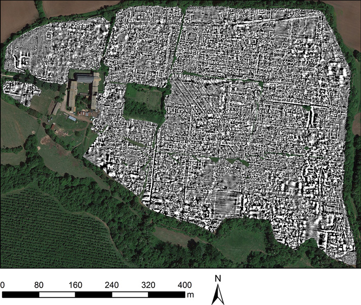
According to ancient Irish history and myth the high kings of Ulster, who ruled from about 1000BCE to 500CE, resided at a place known as Emain Macha. Today that site is called Navan Fort and is located just outside of the town of Armagh in Northern Ireland.
Navan Fort, ancient Emain Macha in what id today Northern Ireland. (Credit: Smithsonian Magazine)
Just how much of those ancient records are history, and how much are myth is often difficult to tell, that’s why the discoveries made by archaeology are so important in helping us to separate fact from fiction. Now a new study of Navan Fort is giving preliminary indications that there are more structures hidden in the soil than previous studies had found, that we’ve literally only just scratched the surface of the archaeological remains at Emain Macha.
Ancient manuscript telling the Irish myth of Cul Dreimhe (The Wild Geese). How much of these stories are based on actual events is unknown. (Credit: The Wild Geese)
The
study was conducted by Queen’s University in Belfast but because the site is a
well known historical and tourist attraction none of the usual digging
associated with archaeology was conducted. Instead the researchers, led by
study authors James O’Driscoll, Patrick Gleeson and Gordon Noble surveyed the
site using high tech, non-invasive tools such as those I described in my post
of 27 June 2020.
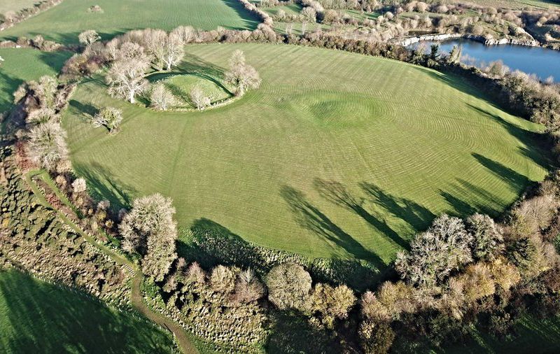
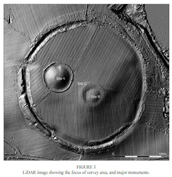
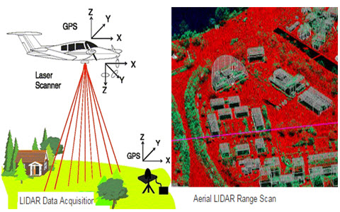
The scientists began their work with an aerial mapping of the site conducted by a technique known as LiDAR. The LiDAR instrument uses laser beams similar to those in a bar code scanner to sweep the ground from an airplane in order to construct a point-by-point 3D contour model of the entire site. LiDAR scans are so precise and accurate that small bumps and gullys that are imperceptible on the ground become clearly visible in a LiDAR generated plot. See image below.
(Credit: O’Driscoll, Gleeson and Noble)
Airborne LiDAR scans the ground with a laser beam generating an extremely accurate 3D model of the surface. (Credit: Abhipedia)
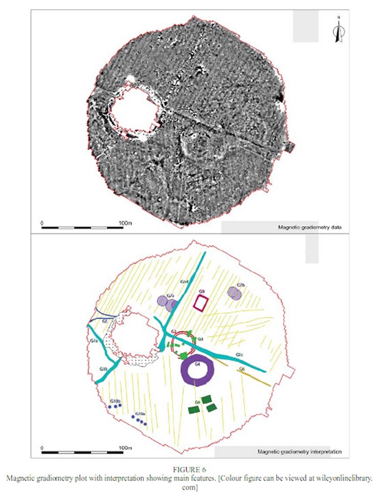
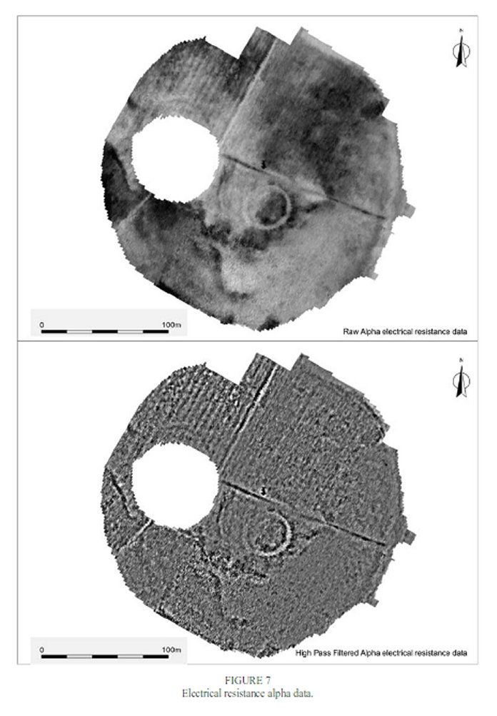
Having obtained a LiDAR survey of the entire site the researchers followed up their high altitude study with ground level Magnetic Gradiometry and soil Electric Resistance measurements. See images below.
(Credit: O’Driscoll, Gleeson and Noble)(Credit: O’Driscoll, Gleeson and Noble)
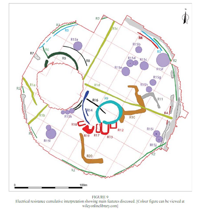
When assembled into one map of the entire site the multiple readings reveal a large number of hidden, subsurface structures within the main outer ring of the fort. See image below.
(Credit: O’Driscoll, Gleeson and Noble)
Of particular interest to the archaeologists was a number of what appears to be two circular structures overlapping each other and forming a figure eight shape. While round houses are typical throughout the ancient Celtic world the purpose of these overlapping figure eights is currently unknown. That’s the problem with the high tech, non-invasive techniques, while they may shown the location and general shape of what’s hidden under the ground they can’t reveal exactly what those structures are nor precisely when they were built and occupied. To answer those questions it is necessary to do some actual digging.
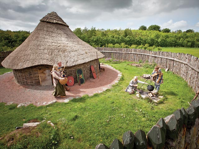
During the Iron Age a typical Irish farmstead would consist of a roundhouse surrounded by a wooden fence. The new survey of Navan Fort has uncovered evidence of many such structures. (Credit: Virtual Visit Tours)
This is not the first time that Navan fort has been surveyed by archaeologists, excavations carried out during 1960s and 1990s discovered the largest known building dating from prehistoric Ireland, a 40m diameter roundhouse. Like Stonehenge in England however Navan fort is important both historically and culturally so any actual digging that takes place there must be carried out sparingly and carefully.
Like Stonehenge, Navan Fort is an archaeological site that is so famous and culturally important that extra special permission is required to disturb it in any way. (Credit: The New York Times)
It was in the hopes of acquiring the funding for actual excavations that the archaeologists at Queen’s University conducted their high tech examination. By first using non-destructive instruments to locate hidden structures the scientists can concentrate on the most interesting areas, hoping to not only get the most bang for their buck but the most discoveries for each shovel full of dirt.
The stories associated with Navan Fort are rooted deep in Irish culture. Most famously the location plays a prominent part in the Ulster Cycle of stories as the home of the hero Cù Chulainn, Conchobar mac Nessa the king of Ulster and Deirdre the most beautiful woman in Ireland.
Known as the Hound of Ulster, Cu is Irish for Dog, Cu Chulain is the hero of a large cycle of myths central to Irish culture. (Credit: Twitter)
Whether of not archaeology can ever provide evidence that those legendary characters ever lived is questionable, but it is the only way we have of learning something about how it was that the people of those times lived.
In the early days of archaeology the only way that an archaeologist could be certain whether or not a potential site was worth excavating was to actually start digging. Even finding a few coins or broken pieces of pottery on the surface only gave a general idea of where more artifacts might lay buried. Many days, weeks and even months could be wasted in fruitless digging just ten or twenty meters away from major discoveries.
When archaeologist Heinrich Schliemann went searching for the ruins of Troy all he had to go on were local stories about where the city lay buried. He got lucky but destroyed much of what he was looking for in his blind attempts at excavation. (Credit: Magnolia Box)
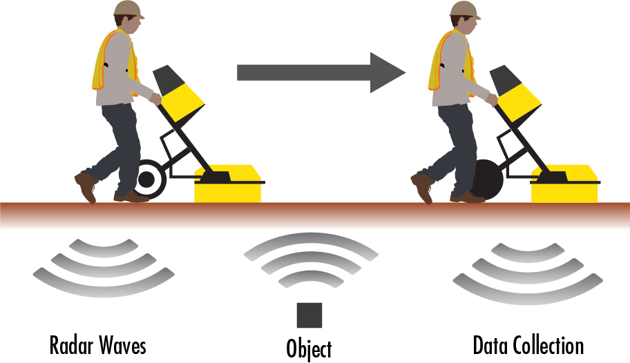
Enter modern technology, in particular the development of Ground Penetrating Radar (GPR). Like the better known version of radar used to locate and track objects in the sky GPR transmits a pulse of electromagnet (EM) energy and then receives the echoes that bounce back from any objects that are struck by the pulse. Of course the difference is that in GPR the pulses are aimed into the ground and are capable of not only detecting objects hidden in the soil but also changes in the material of the soil, say from loose sand to denser clay, or from soil to a buried stone wall.
Principle of Ground Penetrating Radar. (Credit: KCI Technologies)
GPR
is not without its problems, for example wet clay readily absorbs the EM energy
limiting the depth in which anything might be found. Also, since a GPR set must
be dragged across the ground, rocky, uneven terrain makes using GPR difficult.
In addition, GPR cannot always distinguish between natural or man-made objects
that are buried in the ground, in order to be certain you often have to dig it
up.
In
spite of these drawbacks GPR is being employed more and more often in the
earliest stages of an archaeological expedition. In fact a recent
archaeological survey has gone further than ever before in exploiting the
capabilities of GPR. A team of archaeologists from the University of Cambridge
in the UK and Ghent University in Belgium has succeeded in mapping the entirety
of an ancient Roman town using GPR.
Located just a short distance north of Rome the ancient town of Falerii Novi was a typical walled Roman town some 75 acres in size. During its heyday in the second and third centuries BCE Falerii Novi had a population of between two or three thousand people. Such a large site would require many years to excavate using traditional techniques so instead the decision was made to use GPR in order to locate the most interesting areas within the town.
Ground Penetrating Radar image of Falerii Novi superimposed on an aerial photograph of its actual location. (Credit: Archaeology Magazine)
Several
factors combined in making the Falerii Novi a good choice for the first such
extensive use of GPR. The terrain at the location where the small town was
known to have existed was smooth and flat over a wide area while the
composition of the soil was nice and sandy.
The full map of Falerii Novi required the collection of over seventy million readings with the GPR and a total of 28.68 billion data points. Thanks to that full map however the archaeologists have been able to locate many of the town’s important structures such as the local temple as well as the marketplace and a possible Roman bath.
GPR image of what is presumed to be the ancient Temple at Falerii Novi. (Credit: Archaeology Wiki)
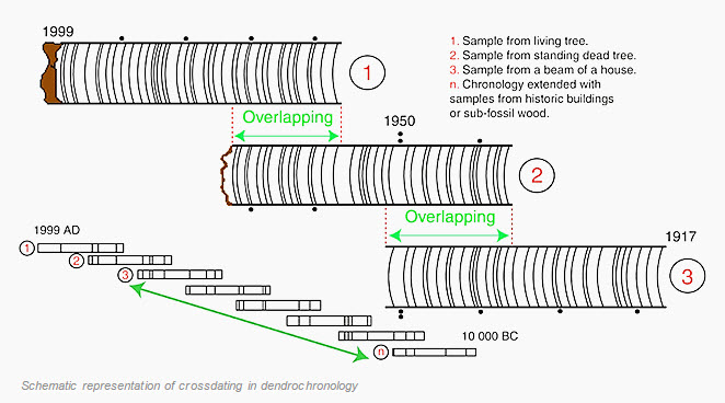
By allowing archaeologists to quickly locate those areas of a site that are most promising for excavation Ground Penetrating Radar has become one of the most useful instruments in the archaeologist’s toolbox. But if GPR helps archaeologists locate where in space the artifacts they are searching for may be found they require other hi-tech tools in order to locate what period in time those same artifacts come from. Two of the most important and accurate techniques that archaeologists use to determine the dates of the ancient sites they study are carbon-14 and tree ring dating, formally known as dendrochronology. Now, for the first time these two techniques have been combined to precisely date the building of one of the most mysterious ancient sites known.
How the tree rings from different, in some cases ancient trees can be used to date archaeological sites. (Credit: Archaeology Magazine)
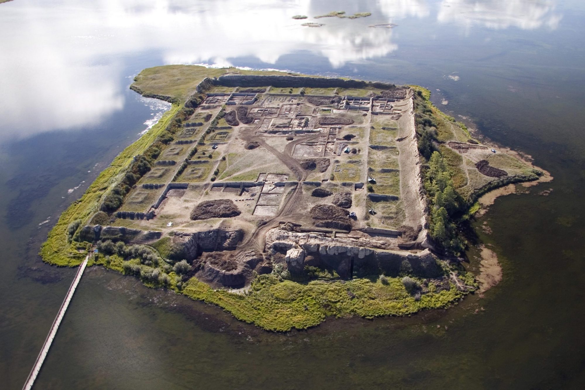
The deserted clay walled city of Por-Bajin is situated on an island in a lake in the Siberian region of Russia not far north of the border with Mongolia. Despite being in the middle of one of the most arid and least populated places on Earth the grassy steppes of central Asia are dotted with the ruins of cities like Por-Bajin that sprang up seemingly out of nowhere, flourished for a century or two and then fell into obscurity. Many, but not all of these ‘ghost towns’ were associated with the famous ‘Silk Road’ the trail of caravans that connected the Middle East with China for more than a thousand years.
The Silk Road was a series of caravan routes connecting Europe with China. Because of the wealth that flowed along that road many now forgotten cities and kingdoms flourished for a few centuries before vanishing into history. (Credit: Chinasage)
Based upon earlier expeditions by Russian archaeologists Por-Bajin was thought to have been built during the 8th century by the ethnic Uyghurs. If these estimates were true the question was then whether the founder of Por-Bajin was the great Uyghur Khan Moyanchur or his successor Bögü. In either case not long after its founding there is evidence that Por-Bajin became a monastery of the eastern ‘Manichaean’ version of Christianity. Then, after only about a century of occupation Por-Bajin suffered a devastating earthquake that caused a collapse of the southern and eastern walls and triggered a fire that destroyed most of the city’s buildings. The site was abandoned shortly after that although some investigators have speculated that Por-Bajin was actually deserted before the earthquake and point to the almost total lack of artifacts or provisions found there as evidence that the site was in fact empty when the earthquake struck.
The ruined city of Por-Bajin. Built in the 700s and abandoned less than a century later it had remained virtually untouched for more the 1200 years. (Credit: SciTechDaily)
Previous dating of the site by the Carbon-14 technique had given a date in the latter half of the 8th century; see my post of June 20th, 2018 for a description of Carbon-14 dating. But now a new study from the Center for Isotope Research at the University of Groningen in the Netherlands along with Lomonosov Moscow University in Russia have combined Carbon-14 dating with tree ring data from other areas of the world to give a much more precise dating for the founding of Por-Bajin.
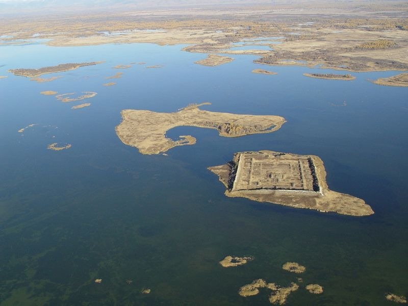
A more distant view of Por-Bajin giving a better idea of how isolated the site is. (Credit: Amusing Planet)
Normally the use of tree rings to date archaeological sites requires that the wood from a particular site be compared to tree rings from wood at an already reliably dated site within the same climate so that the widths of the tree rings can be matched up, see my post of April 18th, 2020 for a description of using dendrochronology to date archaeological sites. Unfortunately the wood from Por-Bajin could not be easily compared to any known useful set of already dated tree rings however.
However the Archaeologists succeeded in finding one tree ring that possessed a spike of carbon-14, a spike that had been recognized in 2013 as existing in tree rings from wood around the world and was reliably dated to the year 775. Based upon the discovery of the spike in wood from Por-Bajin the archaeologists can now definitely say that the founding of the city took place in the year 777 CE, a date that eliminates Khan Moyanchur as it’s possible builder.
Thanks to the combining of Carbon-14 dating and Dendrochronology. Historians now know exactly when and by whom Por-Bajin was built. This will give them a much better chance of figuring out why it was built. (Credit: PNAS)
So by combining their dating methods the scientists had been able to definitively answer a question that had been a mystery for over a thousand years. Por-Bajin may be the first time that archaeologists have combined the two dating techniques of Carbon-14 and Tree Rings but you can be certain that it won’t be the last. Together with Ground Penetrating Radar and the other hi-tech instruments now being employed at ancient dig sites these new tools will enable archaeologists to better understand the history of all of our cultures.
Our Stone Age ancestors, often dismissively referred to as ‘Cave Men’ are usually portrayed in movies and TV as being hardly more intelligent than the animals they hunted, or were hunted by. Little by little however archaeologists are uncovering evidence that Stone Age peoples were capable of flashes of genius in solving the problems they faced despite their lack of resources or tools.
Our Stone Age ancestors certainly had it rough but they still possessed technology way beyond that of any animal they completed with! (Credit: Wikipedia)
Finding food is of course the biggest problem any animal faces and a large part of the success of our species, Homo sapiens is the wide variety of different kinds of food we eat, and that includes seafood. Think about it, what are we, an ape scarcely out of the jungle trees doing eating not only fish but clams and mussels, squid and even whale meat.
We humans enjoy a wide variety of food from the oceans, lakes and rivers. No other primate consumes such an abundance of seafood which begs the question, when did we start? (Credit: Miss Vicki Pressure Cooker)
Over the last several decades anthropologists have even developed the hypothesis that it was learning how to make use of the food resources they found along the coast of West Africa that spurred a small population of Homo erectus to become H sapiens. There has even been speculation that the brain boosting fatty acids in the seafood those H erectus ate might have contributed to the growth of the larger brains of their descendants, that’s us.
Homo erectus is generally considered to be our direct ancestor. Was it learned to live off of seafood that turned them into us? (Credit: Ancient News)
Nice
idea, but there’s new evidence coming from the field that is starting to show
that other species of humans were also learning how to feast off of the bounty
of the sea. I’m talking about our cousins the Neanderthals in Europe as much as
106,000 years ago.
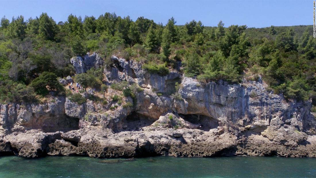
The new evidence comes from a cave site along the southern coast of Portugal at Figueira Brava near the town of Setubal. The interior of the cave has been excavated by a team of archaeologists led by Doctor Joăo Zilhăo from the University of Barcelona in Spain.
The cave complex at Figueira Brava in Portugal. It’s easy to see that any inhabitants would be likely to start eating some of the food right on their doorstep. (Credit: CNN.com)
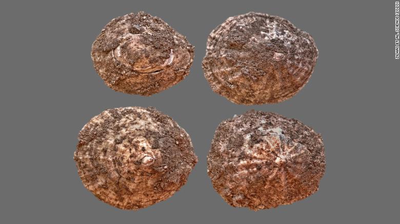
Those excavations have unearthed the bones and other indigestible remains of the animals that the Neanderthals were eating. Those remains clearly show that the Neanderthals were not only hunting the local land fauna of deer, goats, ancient cattle and even horses but were also catching and consuming large amounts mussels, crabs and such fish as eels and sharks! Even the bones of sea mammals like seals and dolphins were discovered in the garbage piles left by the Neanderthals. In fact Doctor Zilhăo and his team estimate that just about half of the diet of the inhabitants of Figueira Brava was in fact seafood.
Patella vulgata shells, a kind of edible snail from the cave at Figueira Brava. (Credit: CNN)
Cracked crab claws from the cave. (Credit: CNN)
So it seems as if our direct ancestors were not the only humans smart enough to realize the enormous benefits to be gained from dinning off of seafood.
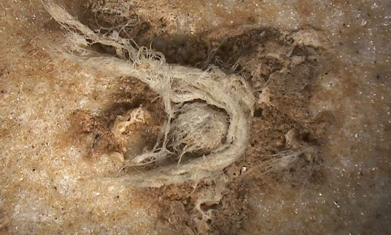
Another recent discovery that also demonstrates the intelligence of Neanderthals is the unearthing of the earliest known piece of string from a site in Abri du Maras in southern France. According to the study co-authored by Marie-Hĕlĕne Moncel, Director of Research of the French Nation Centre for Scientific Research (CNRS) the string fragment is dated to between 41,000 and 52,000 years ago. Composed of fibers from the inner bark of a conifer tree the section measures 6.2mm in length by 0.5mm in maximum width.
Fragment of string that’s over 40,000 years old. (Credit: Phys.org)
The string fragment is more than just a few fibers twisted together however. In fact the fragment consists of three separate twisted cords that have been interwoven together, indicating a considerable level of experience in textile production. But more than that the fragment also indicates a considerable knowledge of available natural resources since the fibers come from the inner part of the bark of a tree that, according to botanists, is best obtained during the spring or early summer.
The discovery of this single strand of cord opens up the possibility that Neanderthals may have made extensive use of textiles, perhaps to manufacture bags, nets, ropes, mats or perhaps even cloth? In any case this, oldest piece of string provides further evidence that Neanderthals were anything but brutish animals.
Moving a bit forward in time, to about 25,000 years ago we begin to see the first evidence for actual construction projects by human beings. Some of the most interesting sites come the fertile steppes of Russia south east of Moscow. Here Stone Age hunter-gatherers lived off of one of the largest and most dangerous animals ever pursued by humans, woolly mammoths.
There is plenty of evidence that our Stone Age ancestors did in fact hunt the massive and dangerous Wholly Mammoth. (Credit: The Vintage News)
We know that our ancestors hunted those ice age relatives of elephants because they had the curious habit of building circular walls out of the bones of the mammoths they killed. In a paper published in the journal Antiquity a team led by Alexander Dudin of the Kostenki Museum-Preserve describes the latest, and largest of these mammoth bone structures. Unearthed about 500 kilometers south of Moscow at a site known as Kostenki 11, the ring measures more than 12 meters across and was made from the bones of at least 60 of the huge beasts.
The ring of Mammoth bones at Kostenki 11. (Credit: New York Times)
Because
the other mammoth bone structures found across Eastern Europe are smaller than
the new one at Kostenki scientists had speculated that the circular walls had
once possessed roofs and were used as shelters by the people who made them. At
12 meters across however the mammoth bone circle at Kostenki is too large to be
easily roofed in, leaving the researchers to think of some other possible usage
for the structure.
Whatever
purpose the hunter-gatherers may have had when they built the structures like
Kostenki the fact that they did so clearly shows that like modern humans they
felt the need to adapt their environment to suit their needs by building.
While
it’s true that the earliest structures we humans built were probably used as
dwelling places there is evidence that by 7000 years ago people were already
learning how to build other types of structures as well. Archaeologists in the
Czech Republic have recently discovered a well that they assert is the oldest
known wooden structure.
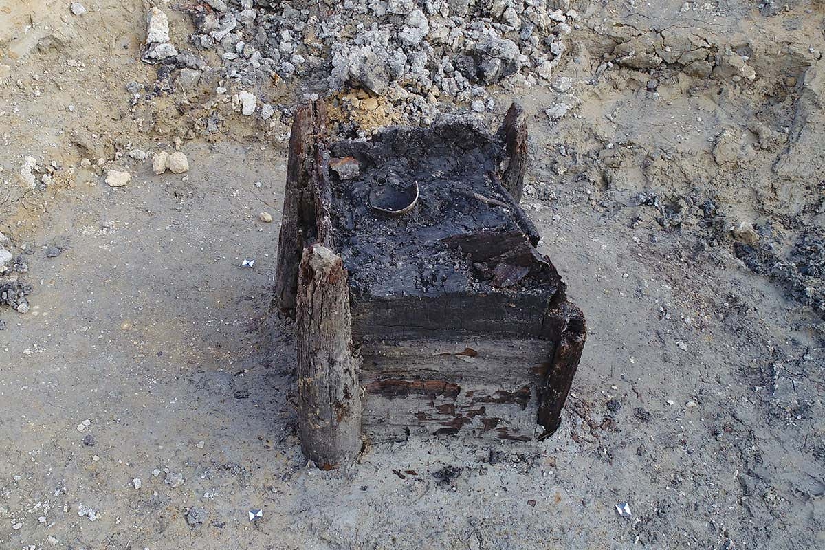
In a study co-authored by Jaroslav Peška head of the Archaeological Centre in Olomouc the well is described as being built in a square shape some 80 cm to a side and 140 cm in height. Each corner of the square consisted of a vertical oaken tree trunk that had been grooved on its sides to allow flat wooden planks, also oak, to be inserted between them to make the square’s sides. This degree of woodworking ability particularly impressed the researchers. “The shape of the individual structural elements and tool marks preserved on their surfaces confirm sophisticated carpentry skills,” they wrote.
7,000 year old well unearthed in the Czech Republic. The woodworking skills of the makers are still evident after all these years. (Credit: New Scientist)
The technique that was used by the archaeologists to date their discovery is known as dendrochronology and is based on an analysis of the tree rings in the well’s wood. Over the past 50 years or so the tree rings in the wood found at many different archaeological sites across Eastern Europe, and from many different time periods, have been matched up, one to another in order to create a exact timeline that can now be used to very precisely date the wood unearthed at any ancient site in Eastern Europe. This same technique has also been developed in other areas of Europe and the different areas of North America and has been used to precisely date many archaeological sites. Using dendrochronology Doctor Peška and his colleagues have succeeded in dating the year that the trees were felled to either 5255 or 5256 BCE.
By comparing the tree rings in wood from different sites archaeologists have developed an extremely accurate dating technique called dendrochronology. (Credit: Museum of Ontario Archaeology)
As
different as these three archaeological discoveries are, each in its own way
demonstrates that, for all of their primitive tools and crude materials our
ancestors nevertheless were able to think up clever solutions to the problems
they faced in their daily lives. In fact think about it, if they hadn’t been so
bright, we’d still be living in caves ourselves wouldn’t we!
‘Dead men tell no tales’ the saying goes but I think archaeologists would argue with that. Much of what we have learned about the past has been obtained by studying the mortal remains excavated from ancient graves and the material goods that have been interred with them. Two recently published papers illustrate this point rather well. I’ll begin with a story about the ‘Black Death’ in 14th century England.
During the ‘Black Death’ epidemic of the mid 1300s a third of the entire human race died during a span of less than ten years. (Credit: Cosmos Magazine)
Entering Europe through Sicily in October of 1347 the bubonic plague sweep across the continent, reaching the British Islands in August of 1348. In cities like London the disease was so deadly that people died by the thousands leading to an almost complete breakdown of social norms. So many died that the time honoured customs of Christian burial were abandoned and the plague’s victims simply thrown into mass graves, several of which have been discovered and excavated by archaeologists.
A mass grave in Toulouse France dated to the time of the bubonic plague. (Credit: Science)
In
rural areas however the death toll was somewhat lower, enough so that some of
the usual customs for honouring the dead continued to be carried out. To date
only one mass grave associated with the plague has been discovered in the
English countryside and a recent study published in the journal Antiquity gives
evidence that even in these troubled times the country folk still did what they
could to show respect for their dead.
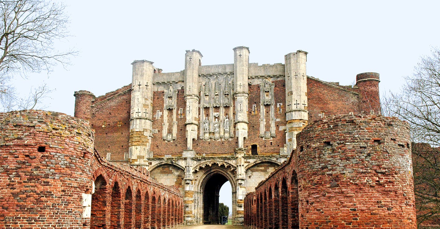
The mass grave was discovered in 2012 on the grounds of Thornton Abbey and contains the remains of 48 men, women and children of all ages. The location of the grave itself is curious because the local church, and its graveyard, is less than two kilometers away, so why weren’t the plague victims buried there? The researchers, led by Hugh Willmott of the University of Sheffield, speculate that perhaps the local priest and gravediggers had succumbed to the plague themselves so that the local people were forced to turn to the Abby’s monks for help.
Thornton Abbey may still look impressive from the front but there’s actually no building left behind the front gate you see here! (Credit:English Heritage)
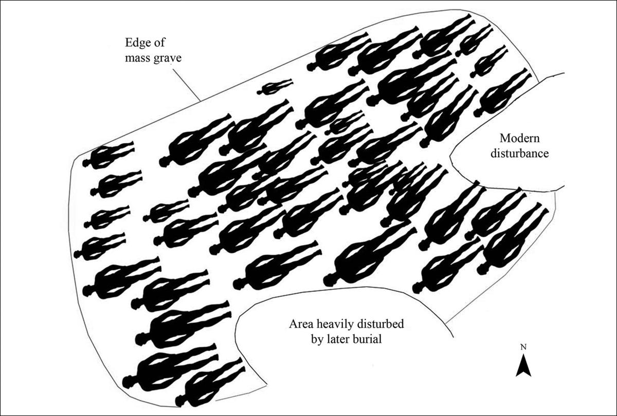
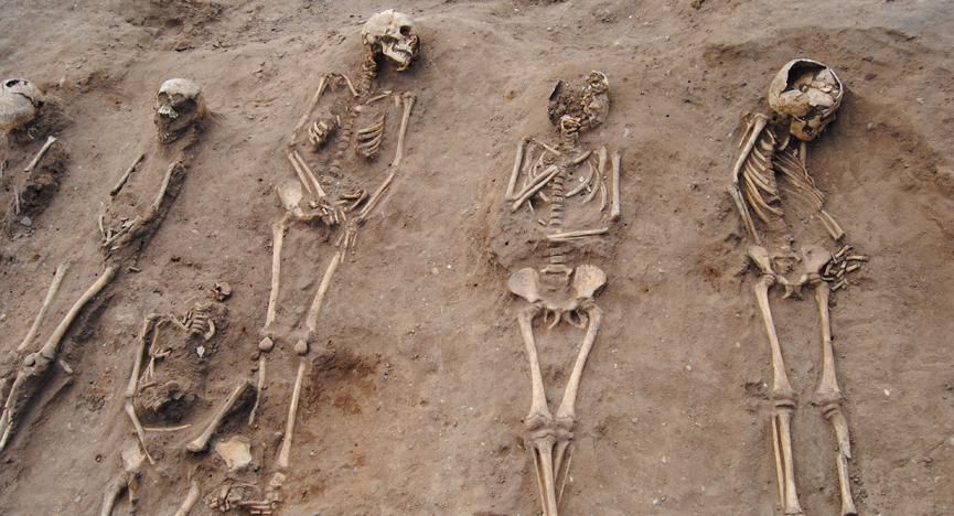
DNA analysis of samples taken from the molars of 16 individuals showed the presence of the bacteria Yersinia pestis, the germ that causes the bubonic plague. This leaves no doubt that the people buried in the mass grave died of the plague and were therefore highly infectious. Despite the danger however the dead bodies were not simply thrown into a hole in the ground. Rather each body was laid separately in a single layer of eight rows with no overlapping. There were even indications that each body had been covered in a shroud that had since decayed. The treatment of the dead shown at Thornton Abby is further evidence that even while it seemed that the world was collapsing around them people still did what they could to honour the memory of their departed loved ones.
Layout of the mass grave found at Thornton Abbey showing that at least some care was given to the dead. (Credit: Arizona Daily Star)Here’s the cause of all the trouble, the bacteria Yersina pestis. (Credit: Creative Biolabs)The Mass grave at Thornton Abbey shows definite signs of greater care being given to the plague victims. (Credit: Smithsonian Magazine)
Which
brings up the question of just when did human beings first begin to perform
burial rituals for their dead? And could it possibly have been before our
species Homo sapiens ever existed? Turns out that there is growing evidence
that Neanderthals also had burial rites that, if more primitive, nevertheless
still seem very human.
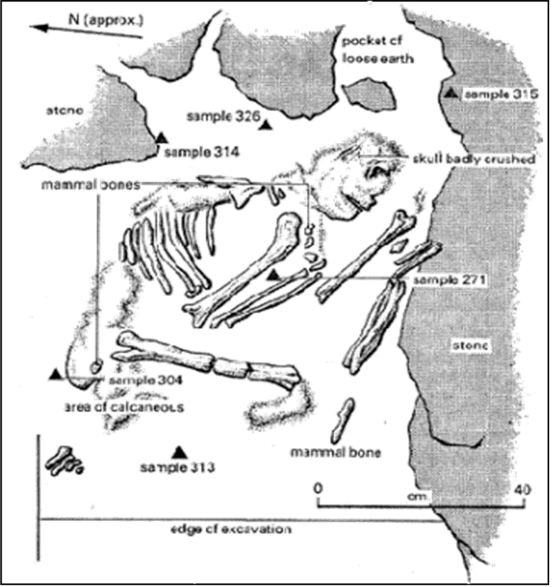
The first such evidence came from excavations in a site in Iraqi Kurdistan known as Shanidar Cave. In the late 1950s and early 60s fragmentary remains of 10 Neanderthal skeletons were discovered in the cave. The big news however was the discovery of clumps of pollen adjacent to one skeleton that the researchers speculated could be the decayed remains of flowers that had been deliberately buried with the dead Neanderthals, a clear sign of some kind of funeral rite.
Shanidar Cave in northern Iraq. (Credit: Science)Layout of the original flower grave at Shanidar. Samples 313 and 314 contained the pollen grains thought to come from flowers left with the deceased. (Credit: Wonderful Things)
At the time that interpretation was very controversial. Critics counter argued that the pollen deposit was accidental, perhaps dropped by some animal. Neanderthals, it was thought, had little or no culture. After all cave paintings were made by Stone Age Homo sapiens, not Neanderthals. The earliest known examples of jewelry and carved figurines were again made by early H sapiens. Neanderthals may have had some stone tools and weapons but their societies were hardly more advanced than a troop of Chimpanzees.
Over
the last several decades however evidence has mounted that Neanderthals did in
fact have some culture, and even something resembling art. Cave markings have
been found that are far too old to have made by H sapiens. Seashells and
semi-precious stones have been discovered in connection with Neanderthal
habitats that indicate they were used as decorations. Neanderthals it seemed
were not as brutish as we’d assumed.
(Of course it’s worth noting at this point that the work of anthropologists like Jane Goodall over the last 50 years have shown that Chimpanzees also have a degree of what can only be described as culture, see my posts of 18Oct2017, 21Mar2018, and 16Mar2019.)
With the growing evidence supporting the funeral ritual interpretation of the burials found in Shanidar Cave you’re think that anthropologists would have returned to the cave in order to see if any further evidence could be found there. Trouble was that for about the last thirty years northern Iraq hasn’t been the safest place to do scientific research. After the recent defeat of the terrorist group ISIS however an archaeological team from Cambridge University returned to Shanidar in 2018 to reexamine the gravesite with the newest instruments and techniques.
Many regions of importance to both Archaeology and Paleontology are inaccessible to science because of the endless wars being fought there. (Credit: Chatham House)
What
the team unearthed were the skeletal remains of the upper body of a Neanderthal
male, including the skull. The remains, which have been dated to 70,000 years
ago, were lying on the person’s back with the left arm curled up so that the
hand lay under the skull. Such a position indicates that the body had been
deliberately arranged rather than simply thrown into a hole. There were also
signs that the grave site for all of the bodies had been deliberately dug and
it is possible that a large stone placed near the skull may have been intended
as a headstone or marker or a sort.
These latest discoveries raise the possibility that the Neanderthals were using Shanidar as a graveyard, a special place for the burial of the dead. According to Emma Pomeroy, an archaeologist with the team. “If Neanderthals were using Shanidar cave as a site of memory for the repeated interment of their dead, it would suggest cultural complexity of a high order.”
Evidence is growing that Neanderthals practiced burial rites that would seem to us as quite human. (Credit: Bones Don’t Lie)
The
way humans care for, respect and remember their dead is one of the things that
most makes us different from our animal relatives. This means that in a sense
the dead can indeed speak, telling us much about what it is to be human.