
In the early days of archaeology the only way that an archaeologist could be certain whether or not a potential site was worth excavating was to actually start digging. Even finding a few coins or broken pieces of pottery on the surface only gave a general idea of where more artifacts might lay buried. Many days, weeks and even months could be wasted in fruitless digging just ten or twenty meters away from major discoveries.

Enter modern technology, in particular the development of Ground Penetrating Radar (GPR). Like the better known version of radar used to locate and track objects in the sky GPR transmits a pulse of electromagnet (EM) energy and then receives the echoes that bounce back from any objects that are struck by the pulse. Of course the difference is that in GPR the pulses are aimed into the ground and are capable of not only detecting objects hidden in the soil but also changes in the material of the soil, say from loose sand to denser clay, or from soil to a buried stone wall.
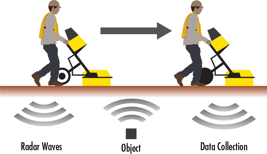
GPR is not without its problems, for example wet clay readily absorbs the EM energy limiting the depth in which anything might be found. Also, since a GPR set must be dragged across the ground, rocky, uneven terrain makes using GPR difficult. In addition, GPR cannot always distinguish between natural or man-made objects that are buried in the ground, in order to be certain you often have to dig it up.
In spite of these drawbacks GPR is being employed more and more often in the earliest stages of an archaeological expedition. In fact a recent archaeological survey has gone further than ever before in exploiting the capabilities of GPR. A team of archaeologists from the University of Cambridge in the UK and Ghent University in Belgium has succeeded in mapping the entirety of an ancient Roman town using GPR.
Located just a short distance north of Rome the ancient town of Falerii Novi was a typical walled Roman town some 75 acres in size. During its heyday in the second and third centuries BCE Falerii Novi had a population of between two or three thousand people. Such a large site would require many years to excavate using traditional techniques so instead the decision was made to use GPR in order to locate the most interesting areas within the town.
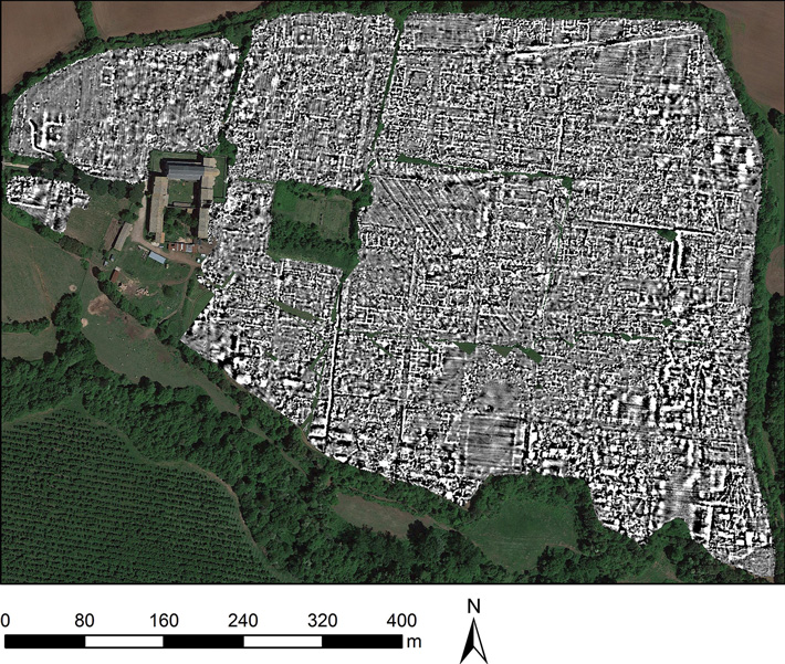
Several factors combined in making the Falerii Novi a good choice for the first such extensive use of GPR. The terrain at the location where the small town was known to have existed was smooth and flat over a wide area while the composition of the soil was nice and sandy.
The full map of Falerii Novi required the collection of over seventy million readings with the GPR and a total of 28.68 billion data points. Thanks to that full map however the archaeologists have been able to locate many of the town’s important structures such as the local temple as well as the marketplace and a possible Roman bath.

By allowing archaeologists to quickly locate those areas of a site that are most promising for excavation Ground Penetrating Radar has become one of the most useful instruments in the archaeologist’s toolbox. But if GPR helps archaeologists locate where in space the artifacts they are searching for may be found they require other hi-tech tools in order to locate what period in time those same artifacts come from. Two of the most important and accurate techniques that archaeologists use to determine the dates of the ancient sites they study are carbon-14 and tree ring dating, formally known as dendrochronology. Now, for the first time these two techniques have been combined to precisely date the building of one of the most mysterious ancient sites known.
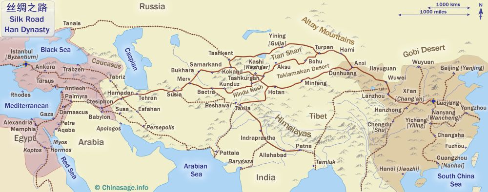
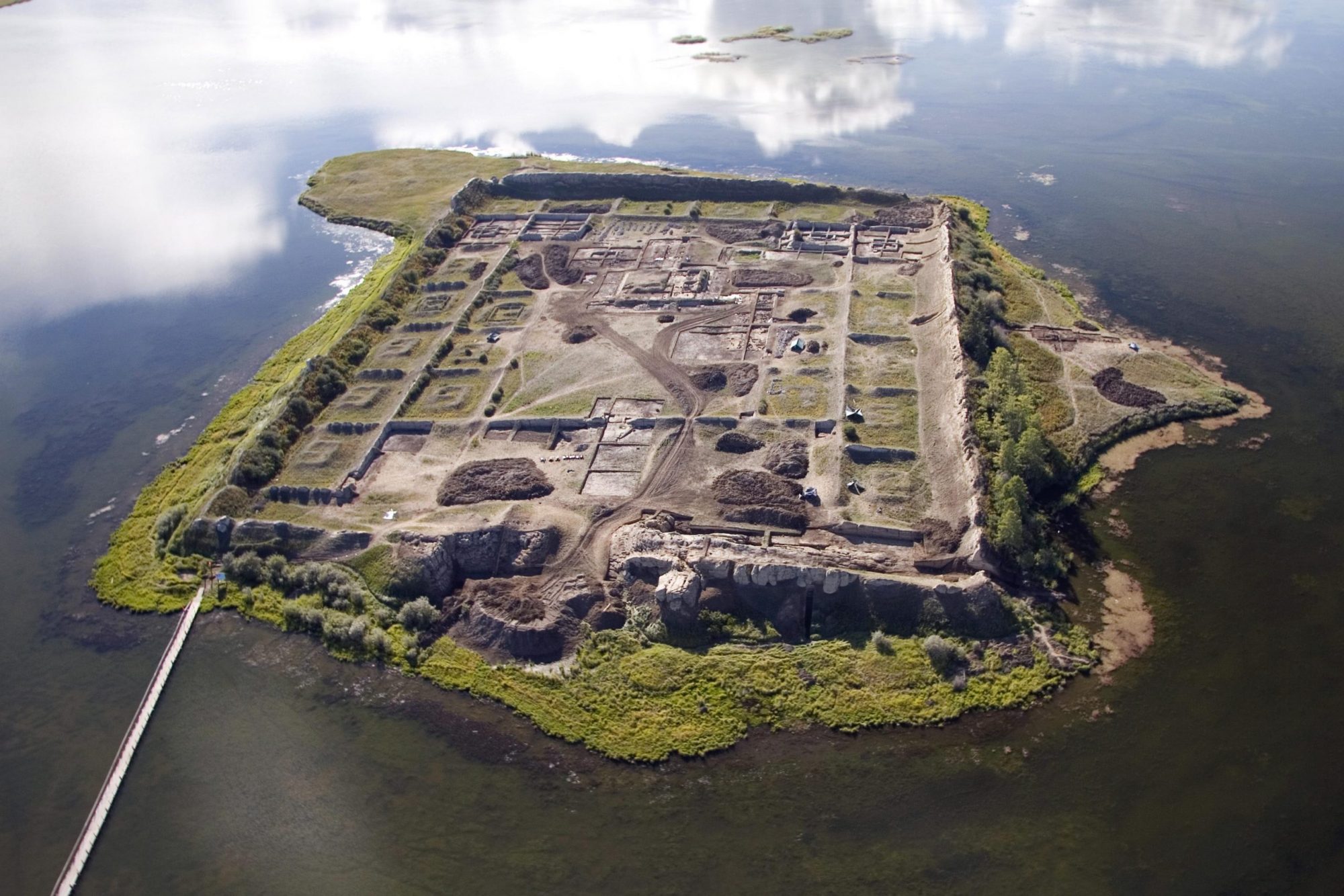
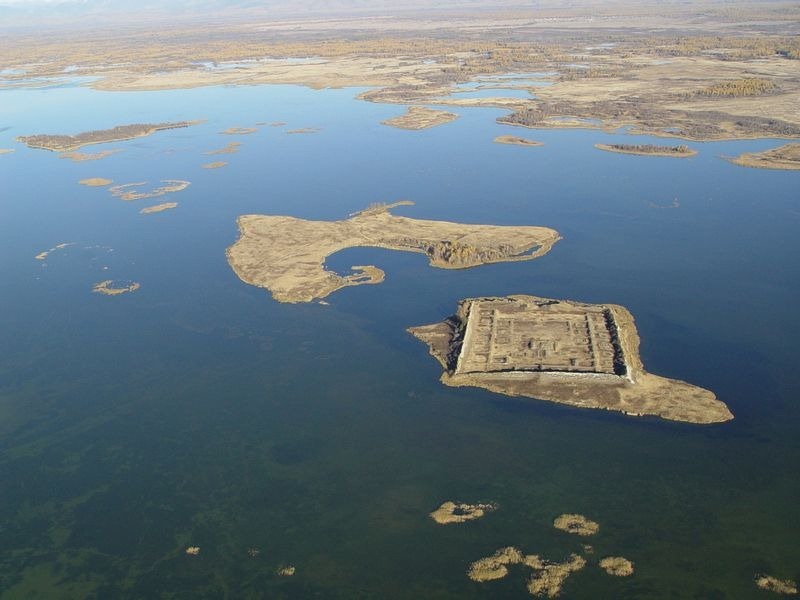
The deserted clay walled city of Por-Bajin is situated on an island in a lake in the Siberian region of Russia not far north of the border with Mongolia. Despite being in the middle of one of the most arid and least populated places on Earth the grassy steppes of central Asia are dotted with the ruins of cities like Por-Bajin that sprang up seemingly out of nowhere, flourished for a century or two and then fell into obscurity. Many, but not all of these ‘ghost towns’ were associated with the famous ‘Silk Road’ the trail of caravans that connected the Middle East with China for more than a thousand years.
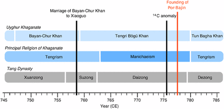
Based upon earlier expeditions by Russian archaeologists Por-Bajin was thought to have been built during the 8th century by the ethnic Uyghurs. If these estimates were true the question was then whether the founder of Por-Bajin was the great Uyghur Khan Moyanchur or his successor Bögü. In either case not long after its founding there is evidence that Por-Bajin became a monastery of the eastern ‘Manichaean’ version of Christianity. Then, after only about a century of occupation Por-Bajin suffered a devastating earthquake that caused a collapse of the southern and eastern walls and triggered a fire that destroyed most of the city’s buildings. The site was abandoned shortly after that although some investigators have speculated that Por-Bajin was actually deserted before the earthquake and point to the almost total lack of artifacts or provisions found there as evidence that the site was in fact empty when the earthquake struck.
Previous dating of the site by the Carbon-14 technique had given a date in the latter half of the 8th century; see my post of June 20th, 2018 for a description of Carbon-14 dating. But now a new study from the Center for Isotope Research at the University of Groningen in the Netherlands along with Lomonosov Moscow University in Russia have combined Carbon-14 dating with tree ring data from other areas of the world to give a much more precise dating for the founding of Por-Bajin.
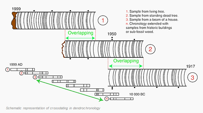
Normally the use of tree rings to date archaeological sites requires that the wood from a particular site be compared to tree rings from wood at an already reliably dated site within the same climate so that the widths of the tree rings can be matched up, see my post of April 18th, 2020 for a description of using dendrochronology to date archaeological sites. Unfortunately the wood from Por-Bajin could not be easily compared to any known useful set of already dated tree rings however.
However the Archaeologists succeeded in finding one tree ring that possessed a spike of carbon-14, a spike that had been recognized in 2013 as existing in tree rings from wood around the world and was reliably dated to the year 775. Based upon the discovery of the spike in wood from Por-Bajin the archaeologists can now definitely say that the founding of the city took place in the year 777 CE, a date that eliminates Khan Moyanchur as it’s possible builder.
So by combining their dating methods the scientists had been able to definitively answer a question that had been a mystery for over a thousand years. Por-Bajin may be the first time that archaeologists have combined the two dating techniques of Carbon-14 and Tree Rings but you can be certain that it won’t be the last. Together with Ground Penetrating Radar and the other hi-tech instruments now being employed at ancient dig sites these new tools will enable archaeologists to better understand the history of all of our cultures.